Accident Scene Data Reports
Accident Scene Data Reports
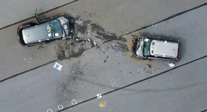
Accident scene data reports are used to reconstruct accidents and determine the cause. These reports include detailed information about the scene, such as photographs, measurements, and witness statements.
Accident scene data reports can be used to:
Reconstruct the accident:
Accident scene data reports can be used to reconstruct the accident, which can help to identify the cause of the accident and to prevent similar accidents from happening in the future.
Determine liability:
Accident scene data reports can be used to determine liability, which can help to resolve insurance claims and lawsuits.
Provide evidence:
Accident scene data reports can be used to provide evidence in court, which can help to win cases.
If you've been involved in an accident, you should consider getting an accident scene data report. Accident scene data reports can be a valuable tool for resolving insurance claims and lawsuits.
Additional Information
In times of disasters and emergencies, our drone services play a crucial role in providing rapid assessment and support to aid response and recovery efforts. Equipped with advanced sensors and imaging capabilities, our drones enable first responders, emergency management teams, and humanitarian organizations to quickly assess the extent of damage, identify potential hazards, and plan effective response strategies.
When natural disasters strike, such as earthquakes, floods, or wildfires, our drones can access areas that are difficult or dangerous for humans to reach. We capture high-resolution aerial imagery and videos, providing real-time visual data that helps prioritize search and rescue operations, assess infrastructure damage, and evaluate the impact on communities. This information is vital for coordinating response efforts, deploying resources, and ensuring the safety of both responders and affected populations.
Our drones also play a crucial role in monitoring and assessing environmental hazards during disasters. With thermal sensors and gas detection capabilities, we can identify hotspots, gas leaks, or chemical spills, providing valuable information for evacuation planning and environmental remediation. By rapidly gathering and analyzing data, we support decision-making processes and help minimize risks to human health and the environment.
In addition to immediate response efforts, our drones assist in post-disaster recovery and reconstruction. By conducting aerial surveys and creating detailed 3D models of affected areas, we facilitate damage assessment, insurance claims, and infrastructure planning. Our drones capture high-resolution imagery that allows for accurate measurements, volume calculations, and documentation, enabling efficient and transparent recovery processes.

Follow us
©Copyright 2023 Florida Drone Pros. All Rights Reserved